


G.E.O.S Sentinel: live military tracker, conflict map and NOTAM monitor on one 3D globe
G.E.O.S Sentinel is the Global Defence Agency’s free, open-source intelligence (OSINT) map. It brings verified conflict events, military aircraft, navy ships, reconnaissance satellites, military bases, NOTAMs and NAVAREA warnings, GPS jamming, satellite heat detections, a nuclear effects simulator and a missile range calculator into one interactive globe that updates around the clock.
What is G.E.O.S Sentinel?
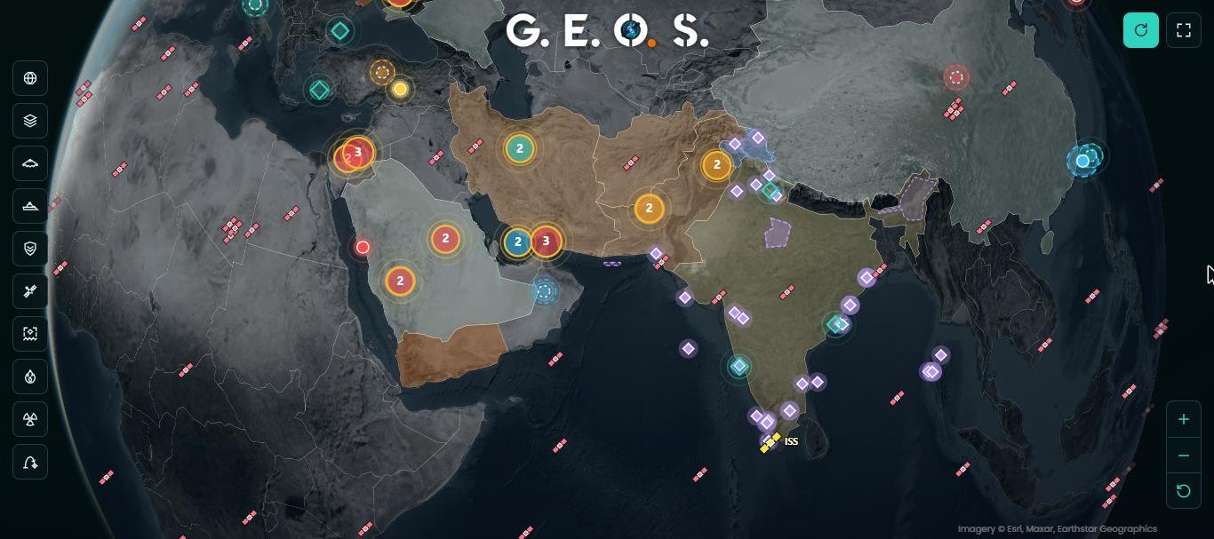
G.E.O.S Sentinel (Global Events & Operations Surveillance Sentinel) is a real-time geospatial dashboard for defence analysts, journalists, students and anyone who follows security affairs. Instead of switching between a flight tracker, a ship tracker, a satellite tracker, a NOTAM portal and several news sites, you see all of them on a single 3D globe, layered on high-resolution satellite imagery.
Every layer can be switched on or off, every marker opens a card with its details and its source, and the map runs on any screen size, from a phone to a large operations-room display. No account and no installation are needed.
The modules at a glance
1. Verified conflict events and military developments
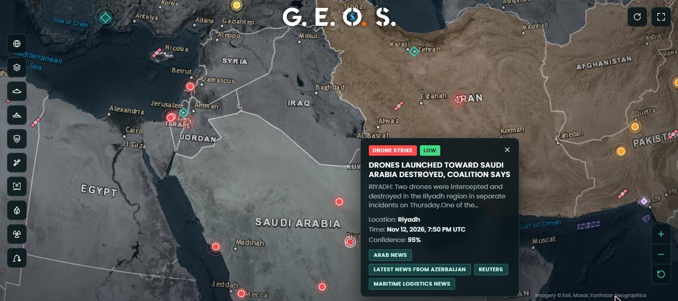
Every hour, G.E.O.S Sentinel reads international and regional news agencies and keeps only reports of a concrete security incident that is happening now. A published rule book decides what qualifies, so the map shows a missile strike, but not a cricket player who “blasts a century”, an anniversary or a road accident.
- Incidents: airstrikes, missile and drone strikes, shelling, bomb blasts and terrorist attacks, attacks on ships, piracy, shoot-downs, military air crashes, missile tests, airspace incursions, border clashes, sabotage of infrastructure, targeted killings, major cyber attacks and coups.
- Developments: defence pacts and arms deals, official warnings, military exercises (shown from their first to their last day), security threats and significant force movements, including carrier groups.
- Placed precisely: the town, port, sea or strait in the report is located on the map; when only a country is named, the marker is drawn dashed.
- Cross-checked: the same event from several outlets becomes one marker that lists every source.
- Always current: incidents leave the map after 24 hours; nothing stays longer than 36 hours except an exercise that is still running.
How an event reaches the map
2. Live military aircraft tracker
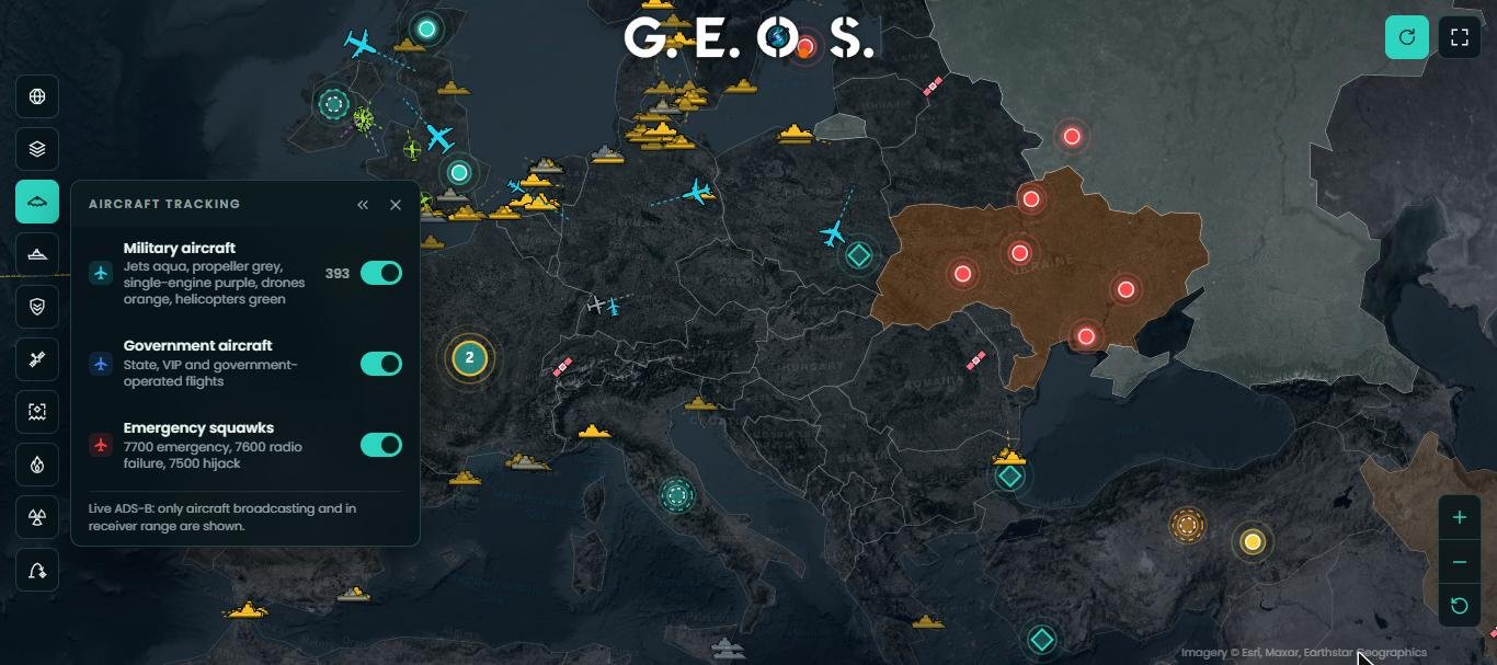
The aircraft layer shows military, government and VIP flights in real time from public ADS-B receivers. Aircraft are drawn by type: fighters and jets, propeller aircraft, drones and helicopters each have their own symbol and colour, and the line behind each aircraft shows its recent track.
- Military aircraft, government and state flights, and emergency squawks (7700, 7600, 7500) as separate layers.
- Click any aircraft for its type, operator, country, altitude, speed and heading.
- Only aircraft that broadcast ADS-B and are within receiver range can be shown; many military flights switch their transponders off.
Source: ADS-B community networks (adsb.lol). Updated continuously.
3. Naval tracker: warships and coast guards
The naval layer shows warships, naval auxiliaries and coast-guard or maritime-police vessels that broadcast AIS. Ship markers are drawn by role, and each card gives the ship’s name, flag, type and last report time. Named aircraft carriers mentioned in the news also get their own marker that moves as new positions are reported, with a dashed line from the last known position.
Sources: AIS data (aisstream.io, Global Fishing Watch). Warships often switch AIS off, so the layer shows what is publicly visible, not the full fleet.
4. Military and reconnaissance satellite tracker
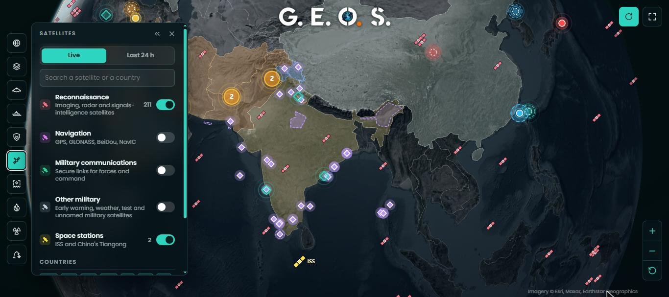
See which imaging, radar and signals-intelligence satellites are passing over a region right now. The satellite tracker computes every position live in your browser from the latest orbital elements.
- Reconnaissance satellites and the space stations (ISS and China’s Tiangong) are shown by default.
- Add navigation (GPS, GLONASS, BeiDou, NavIC), military communications and other military satellites.
- Filter by country, search by name, and switch to the “last 24 hours” view to see how often a region was overflown.
Source: CelesTrak orbital data, refreshed every 10 minutes.
5. NOTAMs and NAVAREA warnings: missile firing and exercise areas
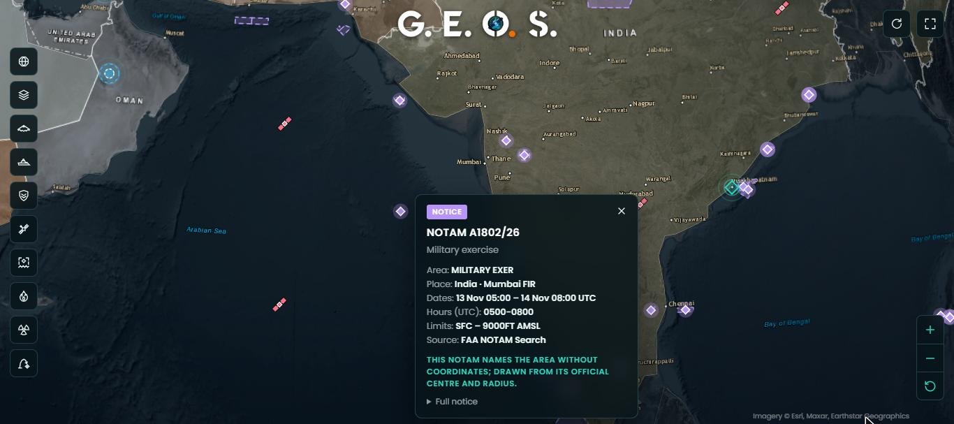
Before a missile test, a naval firing or a large exercise, aviation and maritime authorities publish NOTAMs (Notices to Air Missions) and navigation warnings that close an area of sky or sea. G.E.O.S Sentinel reads these notices and draws each danger area as a polygon, circle, corridor or closed air route.
- Covers India and Pakistan: Pakistan Airports Authority, Airports Authority of India, the FAA NOTAM system, Pakistan Navy NAVAREA IX and coastal warnings, Indian Navy NAVAREA VIII and NGA broadcast warnings.
- Only military notices are kept: missile and rocket firings, gunnery, exercises and active danger areas.
- Each card gives the notice number, activity, area, dates, daily hours, altitude limits and the full original text.
- Notices leave the map automatically at their end time.
6. Military bases map
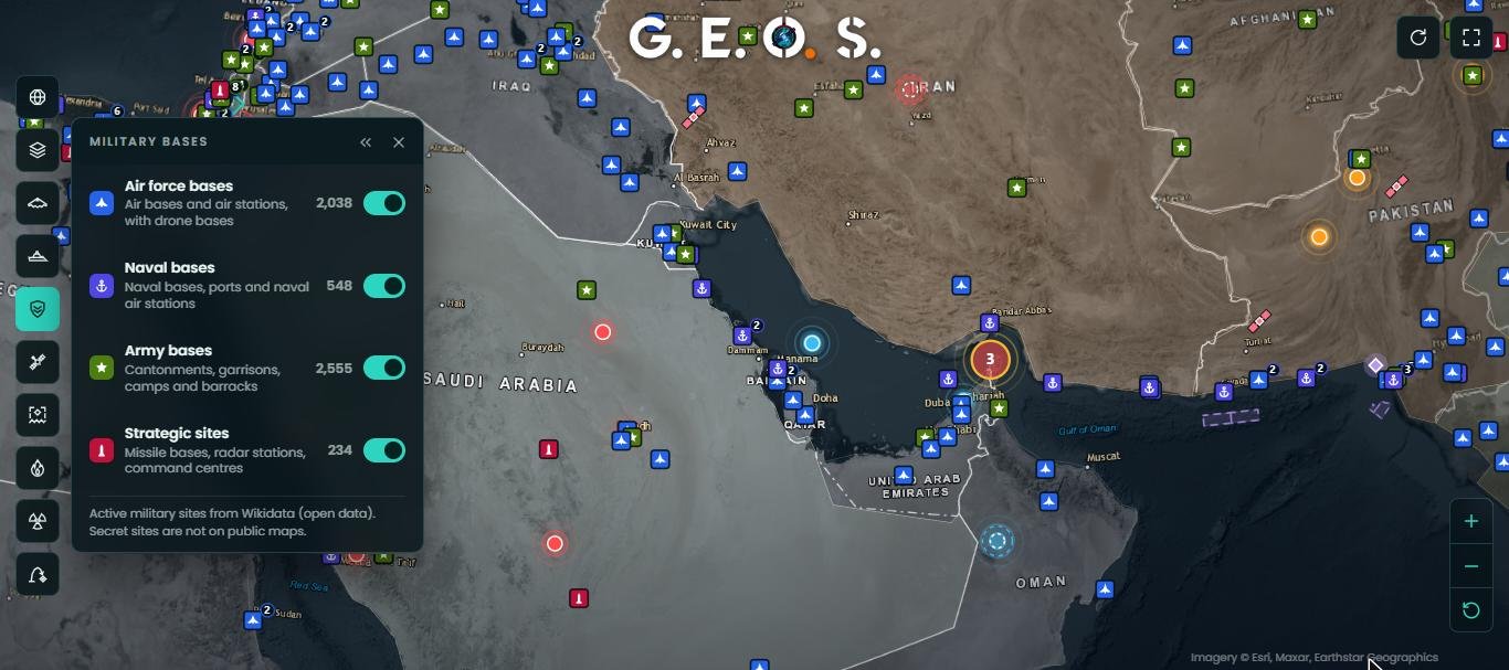
More than 5,300 active military sites, drawn from open data, are grouped into four layers: over 2,000 air force bases and air stations (including drone bases), about 550 naval bases and naval air stations, more than 2,500 army cantonments, garrisons and camps, and over 230 strategic sites such as missile bases, radar stations and command centres. Click a base for its name, branch and country. Secret sites are, by definition, not on public maps.
Source: Wikidata (open data).
7. GPS jamming and spoofing map
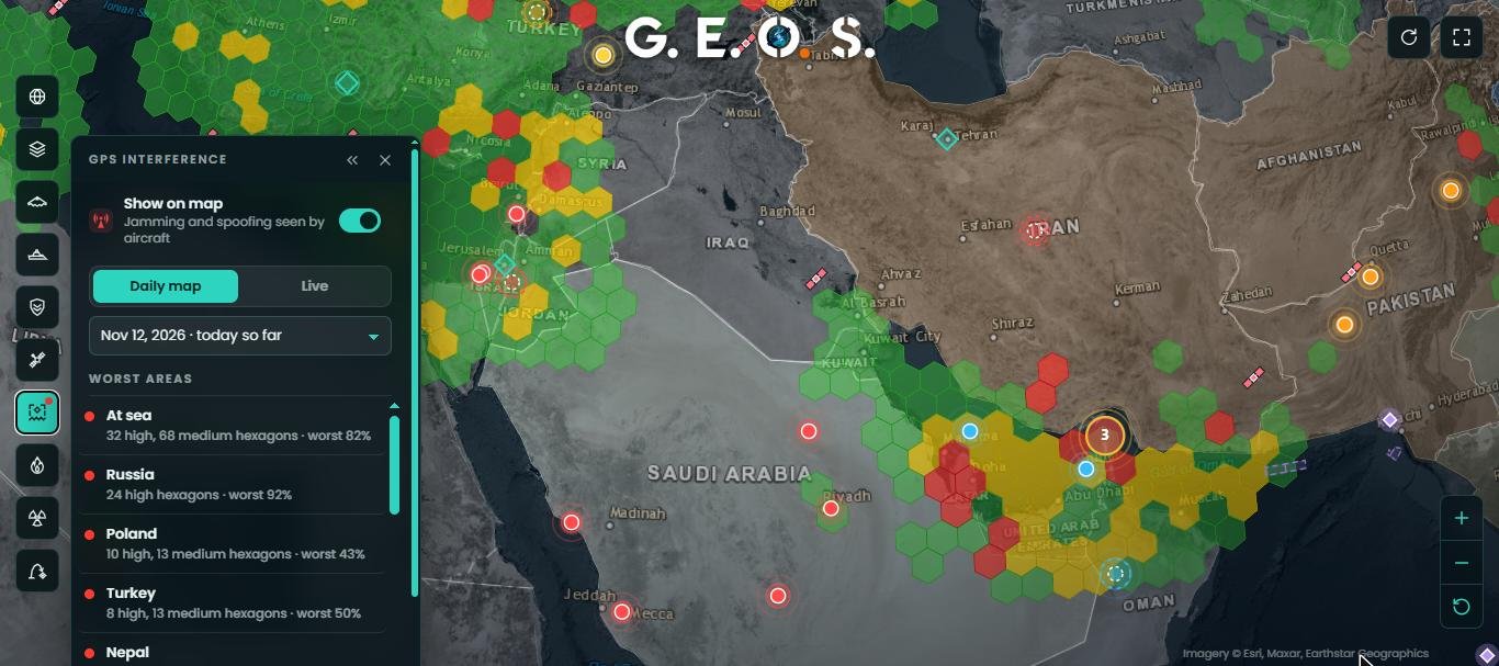
Electronic warfare is now part of every conflict. Aircraft report the quality of their satellite navigation, and where many of them lose accuracy at once, GPS is being jammed or spoofed. G.E.O.S Sentinel turns these reports into a hexagon map.
- Daily map for any recent date, or a live view for the last hour.
- Green, yellow and red hexagons show low, medium and high interference.
- A ranked list of the worst-affected areas and countries.
8. Heat anomalies: fires, strikes and volcanoes seen from space
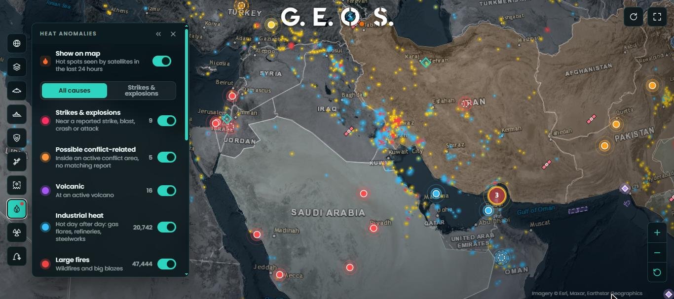
Polar-orbiting satellites detect fires and other hot spots at 375 m resolution several times a day. G.E.O.S Sentinel sorts every detection from the last 24 hours by its likely cause: strikes and explosions (heat near a reported strike, blast, crash or attack), possible conflict-related fires inside active conflict areas, volcanic heat, industrial heat such as gas flares and refineries, and large fires. This makes it possible to see, for example, a refinery burning after a drone attack hours before photos appear.
Source: NASA FIRMS, VIIRS (NOAA-20 and NOAA-21), checked every 3 hours.
9. Nuclear effects simulator
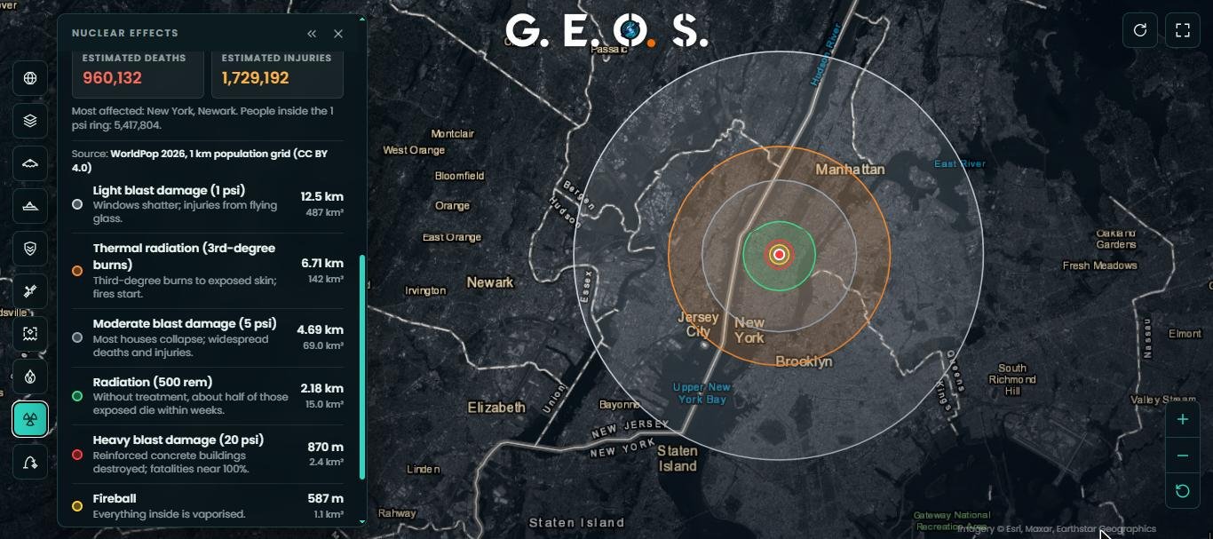
Choose a weapon preset or any yield, an airburst or a surface burst, and a place, and the simulator draws the fireball, heavy, moderate and light blast damage, thermal burns and initial radiation rings on the map.
- Effect radii from US government references (Glasstone & Dolan, 1977; Office of Technology Assessment, 1979).
- Casualty estimates count the people in every 1 km cell inside each ring, using the WorldPop 2026 population grid.
- Fallout plume for surface bursts, following the wind speed and direction you set.
The figures are rough, educational estimates: they count residents, not daytime crowds, and leave out fires and later radiation deaths.
10. Missile range calculator
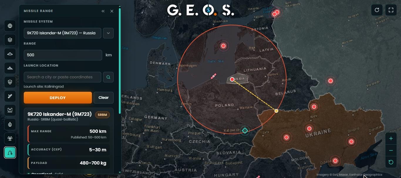
Pick a missile from a database of ballistic, cruise and hypersonic systems from every major military power, or enter any range, then choose a launch point. The map draws the maximum range on the globe and the card lists published range, accuracy (CEP), payload, propulsion and status. Move the launch point or the aim line to see what lies within reach.
11. Country briefs, regions and search
Click any country for its brief and the events in it, or narrow the whole map to one region. Indian-administered Jammu and Kashmir and Ladakh are always shaded in light blue so the line of control is easy to read. A search box finds places, satellites and missile systems, and every layer and panel can be collapsed for a clean full-screen view.
Data sources and update frequency
| Layer | Source | Updated |
|---|---|---|
| Conflict events & developments | International and regional news agencies | Every hour |
| Military aircraft | Public ADS-B networks | Live |
| Navy and coast-guard ships | AIS (aisstream.io, Global Fishing Watch) | Live |
| Satellites | CelesTrak orbital elements | Every 10 minutes |
| NOTAMs & NAVAREA warnings | PAA, AAI, FAA, Pakistan Navy, Indian Navy, NGA | Every two days, daily for some sources |
| Military bases | Wikidata | Periodically |
| GPS interference | Aircraft navigation-accuracy reports | Daily and live |
| Heat anomalies | NASA FIRMS (VIIRS) | Every 3 hours |
| Population (nuclear simulator) | WorldPop 2026, 1 km grid (CC BY 4.0) | Yearly |
Frequently asked questions
Is G.E.O.S Sentinel free to use?
Yes. The map is free, needs no account and works in any modern browser on phones, tablets and desktops.
How is G.E.O.S Sentinel different from a flight tracker or a ship tracker?
It combines military aircraft, navy ships, satellites, military bases, NOTAMs, GPS jamming, satellite heat detections and verified conflict events on one globe, so you can see how they relate: for example, a NOTAM for a missile test next to the aircraft and ships in the area.
How are conflict events verified?
Each report must come from a recognised news outlet, describe a current event, pass a published rule book that excludes old news, statements, sport, follow-ups and everyday accidents, and be placed at the location it names. Reports of the same event from several outlets are merged into one marker that lists all sources.
Which NOTAMs and navigation warnings are shown?
Military NOTAMs and NAVAREA and coastal warnings for India and Pakistan: missile and rocket firings, gunnery, exercises and active danger areas. Civil notices are left out.
Why can’t I see every military aircraft or warship?
The trackers show only aircraft and ships that broadcast ADS-B or AIS and are in range of a public receiver. Many military platforms switch their transponders off on operations.
How accurate is the nuclear effects simulator?
The effect radii follow standard US government references and the casualty estimate counts people in 1 km population cells, but it remains an educational estimate. Real outcomes depend on time of day, buildings, weather and many other factors.
Who runs G.E.O.S Sentinel?
G.E.O.S Sentinel is built and run by the Global Defence Agency (GDA) as part of its open-source defence research.
G.E.O.S Sentinel is built only from publicly available information. Positions, events and estimates can be incomplete or delayed and must not be used for navigation or operational decisions. Imagery © Esri, Maxar, Earthstar Geographics. Population data © WorldPop, University of Southampton (CC BY 4.0).